
Places to visit
Outdoor Activity
A home for mountain bikers from novice to professional, BikePark Wales has the UK's greatest and most diverse selection of all-weather mountain bike trails. With a vehicular uplift service to transport you to the top of the trails, bike and equipment hire, coaching, guiding and a lovely on site café we have everything you need for an incredible day on the mountain. Our new "Ticket to Ride" package is perfect for those who wish to try gravity mountain biking for the first time and for those with years of experience we have trails to test the very best riders in the world.
128 recommandé par les habitants
Bike Park Wales
A home for mountain bikers from novice to professional, BikePark Wales has the UK's greatest and most diverse selection of all-weather mountain bike trails. With a vehicular uplift service to transport you to the top of the trails, bike and equipment hire, coaching, guiding and a lovely on site café we have everything you need for an incredible day on the mountain. Our new "Ticket to Ride" package is perfect for those who wish to try gravity mountain biking for the first time and for those with years of experience we have trails to test the very best riders in the world.
Within walking distance from home...
Accessible lovely walk close to my home. No visit to Parc Penallta is complete without seeing Sultan the Pit Pony. Sultan is the iconic feature of the park. At 200 metres long and 15 metres high he is one of the largest figurative earth sculptures in the country.
13 recommandé par les habitants
Parc Penallta
Penallta RoadWithin walking distance from home...
Accessible lovely walk close to my home. No visit to Parc Penallta is complete without seeing Sultan the Pit Pony. Sultan is the iconic feature of the park. At 200 metres long and 15 metres high he is one of the largest figurative earth sculptures in the country.
Within walking distance from home...
This prancing pony is a 200 metre long raised-earth artwork by Mick Petts that was completed over a period of 3 years. The earthwork is a homage to the pit pony, the last of which was retired in 1999. These animals were used to haul containers of coal in underground coal mines, and the locals later dubbed Mick Petts work ‘Sultan’ after a particularly famous local pit pony.
Penallta Pit Pony -
Within walking distance from home...
This prancing pony is a 200 metre long raised-earth artwork by Mick Petts that was completed over a period of 3 years. The earthwork is a homage to the pit pony, the last of which was retired in 1999. These animals were used to haul containers of coal in underground coal mines, and the locals later dubbed Mick Petts work ‘Sultan’ after a particularly famous local pit pony.
Within walking distance from home...
Hengoed Viaduct is a disused railway viaduct located above the village of Maesycwmmer, in Caerphilly county borough, South Wales. Grade II* listed, it was originally built to carry the Taff Vale Extension of the Newport, Abergavenny and Hereford Railway (NA&HR) across the Rhymney River, and is now part of National Cycle Route 47.
Hengoed/Maesycwmmer Viaduct
Within walking distance from home...
Hengoed Viaduct is a disused railway viaduct located above the village of Maesycwmmer, in Caerphilly county borough, South Wales. Grade II* listed, it was originally built to carry the Taff Vale Extension of the Newport, Abergavenny and Hereford Railway (NA&HR) across the Rhymney River, and is now part of National Cycle Route 47.
Caerphilly Castle (Welsh: Castell Caerffili) is a medieval fortification in Caerphilly in South Wales. The castle was constructed by Gilbert de Clare in the 13th century as part of his campaign to maintain control of Glamorgan, and saw extensive fighting between Gilbert, his descendants, and the native Welsh rulers. Surrounded by extensive artificial lakes – considered by historian Allen Brown to be "the most elaborate water defences in all Britain" – it occupies around 30 acres (12 ha) and is the largest castle in Wales and the second-largest castle in the United Kingdom after Windsor Castle.
117 recommandé par les habitants
Château de Caerphilly
Castle StreetCaerphilly Castle (Welsh: Castell Caerffili) is a medieval fortification in Caerphilly in South Wales. The castle was constructed by Gilbert de Clare in the 13th century as part of his campaign to maintain control of Glamorgan, and saw extensive fighting between Gilbert, his descendants, and the native Welsh rulers. Surrounded by extensive artificial lakes – considered by historian Allen Brown to be "the most elaborate water defences in all Britain" – it occupies around 30 acres (12 ha) and is the largest castle in Wales and the second-largest castle in the United Kingdom after Windsor Castle.
Castell Coch Welsh pronunciation: for 'Red Castle' is a 19th-century Gothic Revival castle built above the village of Tongwynlais in South Wales. The first castle on the site was built by the Normans after 1081, to protect the newly conquered town of Cardiff and control the route along the Taff Gorge. Abandoned shortly afterwards, the castle's earth motte was reused by Gilbert de Clare as the basis for a new stone fortification, which he built between 1267 and 1277 to control his freshly annexed Welsh lands. This castle was likely destroyed in the native Welsh rebellion of 1314. In 1760, the castle ruins were acquired by John Stuart, 3rd Earl of Bute, as part of a marriage settlement that brought the family vast es
168 recommandé par les habitants
Château Coch
Castell Coch Welsh pronunciation: for 'Red Castle' is a 19th-century Gothic Revival castle built above the village of Tongwynlais in South Wales. The first castle on the site was built by the Normans after 1081, to protect the newly conquered town of Cardiff and control the route along the Taff Gorge. Abandoned shortly afterwards, the castle's earth motte was reused by Gilbert de Clare as the basis for a new stone fortification, which he built between 1267 and 1277 to control his freshly annexed Welsh lands. This castle was likely destroyed in the native Welsh rebellion of 1314. In 1760, the castle ruins were acquired by John Stuart, 3rd Earl of Bute, as part of a marriage settlement that brought the family vast es
St. Fagans is an affluent village on the city’s outskirts, known for St. Fagans Castle. This Elizabethan manor has extensive gardens, with fountains, the Italian Garden and a rosery. Also within its grounds, the open-air St. Fagans National Museum of History showcases historic buildings relocated from across Wales, including a farm, a tannery, mills and a chapel. The surrounding countryside is popular with walkers. Free entry however car park charges
328 recommandé par les habitants
St Fagans National History Museum
St. Fagans is an affluent village on the city’s outskirts, known for St. Fagans Castle. This Elizabethan manor has extensive gardens, with fountains, the Italian Garden and a rosery. Also within its grounds, the open-air St. Fagans National Museum of History showcases historic buildings relocated from across Wales, including a farm, a tannery, mills and a chapel. The surrounding countryside is popular with walkers. Free entry however car park charges
Pen y Fan is the highest peak in south Wales, situated in the Brecon Beacons National Park. At 886 metres above sea-level, it is also the highest British peak south of Cadair Idris in Snowdonia. It is the highest point of the historic county of Brecknockshire.
225 recommandé par les habitants
Pen y Fan
Pen y Fan is the highest peak in south Wales, situated in the Brecon Beacons National Park. At 886 metres above sea-level, it is also the highest British peak south of Cadair Idris in Snowdonia. It is the highest point of the historic county of Brecknockshire.
Llancaiach Fawr Manor is a Tudor manor house near the village of Nelson, located just to the north of the site of the former Llancaiach Colliery in the heart of the Rhymney Valley in South Wales. The semi-fortified house was built on the site of an earlier medieval structure, either on top of the previous dwelling or possibly incorporated within the eastern end of that building. It is a Grade I listed building[1] and is now best known as the home of Colonel Edward Prichard (died 1655), who hosted a visit by King Charles I of England in 1645.
27 recommandé par les habitants
Llancaiach Fawr Manor
Llancaiach Fawr Manor is a Tudor manor house near the village of Nelson, located just to the north of the site of the former Llancaiach Colliery in the heart of the Rhymney Valley in South Wales. The semi-fortified house was built on the site of an earlier medieval structure, either on top of the previous dwelling or possibly incorporated within the eastern end of that building. It is a Grade I listed building[1] and is now best known as the home of Colonel Edward Prichard (died 1655), who hosted a visit by King Charles I of England in 1645.
ESCAPE TO NATURE
From thrilling adventures to tranquil overnight stays, Cwmcarn Forest is close enough to retreat to yet feels like a million miles away. Gear up or wind down, the choice is yours; choose from adrenaline fuelled mountain bike trails and water activities or enjoy a stroll around one of the many walking trails and grab a cuppa at the takeaway service in Raven’s Café.
14 recommandé par les habitants
Forêt de Cwmcarn
Cwmcarn Forest DriveESCAPE TO NATURE
From thrilling adventures to tranquil overnight stays, Cwmcarn Forest is close enough to retreat to yet feels like a million miles away. Gear up or wind down, the choice is yours; choose from adrenaline fuelled mountain bike trails and water activities or enjoy a stroll around one of the many walking trails and grab a cuppa at the takeaway service in Raven’s Café.
Big Pit National Coal Museum (Welsh: Pwll Mawr Amgueddfa Lofaol Cymru) is an industrial heritage museum in Blaenavon, Torfaen, Wales. A working coal mine from 1880 to 1980, it was opened to the public in 1983 under the auspices of the National Museum of Wales. The site is dedicated to operational preservation of the Welsh heritage of coal mining, which took place during the Industrial revolution.
13 recommandé par les habitants
Big Pit Mining Museum
Forge SideBig Pit National Coal Museum (Welsh: Pwll Mawr Amgueddfa Lofaol Cymru) is an industrial heritage museum in Blaenavon, Torfaen, Wales. A working coal mine from 1880 to 1980, it was opened to the public in 1983 under the auspices of the National Museum of Wales. The site is dedicated to operational preservation of the Welsh heritage of coal mining, which took place during the Industrial revolution.
During the 12th Century Norman invasion of Wales, the formal parish was defined – an area of more than 30,000 acres (47 sq mi; 120 km2), including Caerphilly.[1]
The parish church of Saint Ilan was built on the ridge between the Taff Valley and Aber Valley, on what was thought to have been the site of an earlier chapel or monastic cell. The parish website speculates that it may originally have been the home of a 6th Century monk.[1] The site lies on the ancient pilgrimage route from Llantarnam to Penrhys.[2]
Originally Roman Catholic, the church became Anglican following the Reformation caused by Henry VIII. In due course, eleven Anglican parishes were founded from it, causing a reduction in the territory remaining with the mother church.[3]
In 1801, the parish had dependent chapels at Llanfabon and St Martin. The resident population was reckoned to number 1885 people, 'residing in the hamlets of Eglwys Ilan, Ener Glynn, Glynn Tâff, Hendredenny, Parc, Rhyd y Byddin, and The Town of Caerphilly'.[3] In 2012, the parish website stated the parish contained 8,000 people 'serving all of the Aber Valley and including the villages of Abertridwr and Senghenydd together with the hamlets of Eglwysilan and Groeswen'.[1] Today, the hamlets of Pen-y-Groes, Eglwysilan and Groeswen are affluent commuter villages house prices significantly above the local average; the communities are inhabited by professionals with a high level of bilingualism.[citation needed]
The churchyard contains the grade II* listed tomb of the bridge builder William Edwards [4] and many of the victims of the Senghenydd Colliery Disaster of 1913. Evan James, who wrote the lyrics of the Welsh National Anthem, was baptised at the church
St. Ilan's Church - Rectorial Benefice of Eglwysilan and Caerphilly
2 Eglwysilan RdDuring the 12th Century Norman invasion of Wales, the formal parish was defined – an area of more than 30,000 acres (47 sq mi; 120 km2), including Caerphilly.[1]
The parish church of Saint Ilan was built on the ridge between the Taff Valley and Aber Valley, on what was thought to have been the site of an earlier chapel or monastic cell. The parish website speculates that it may originally have been the home of a 6th Century monk.[1] The site lies on the ancient pilgrimage route from Llantarnam to Penrhys.[2]
Originally Roman Catholic, the church became Anglican following the Reformation caused by Henry VIII. In due course, eleven Anglican parishes were founded from it, causing a reduction in the territory remaining with the mother church.[3]
In 1801, the parish had dependent chapels at Llanfabon and St Martin. The resident population was reckoned to number 1885 people, 'residing in the hamlets of Eglwys Ilan, Ener Glynn, Glynn Tâff, Hendredenny, Parc, Rhyd y Byddin, and The Town of Caerphilly'.[3] In 2012, the parish website stated the parish contained 8,000 people 'serving all of the Aber Valley and including the villages of Abertridwr and Senghenydd together with the hamlets of Eglwysilan and Groeswen'.[1] Today, the hamlets of Pen-y-Groes, Eglwysilan and Groeswen are affluent commuter villages house prices significantly above the local average; the communities are inhabited by professionals with a high level of bilingualism.[citation needed]
The churchyard contains the grade II* listed tomb of the bridge builder William Edwards [4] and many of the victims of the Senghenydd Colliery Disaster of 1913. Evan James, who wrote the lyrics of the Welsh National Anthem, was baptised at the church
Sat nav for the Angel Inn Pontneathvaughan Road
Pontneddfechan
SA11 5NR (parking near by)
long circular walk explores the rivers and waterfalls in the Vale of Neath, also known as 'Waterfall Country'. It's a spectacularly beautiful area with a huge number of waterfalls to see. The falls are of varying size with some of them allowing you to walk behind them for a really special experience.
This route runs for about 9 miles on generally good footpaths with some moderate climbing as you cross the countrsyide between the two woodland gorges.
The route starts in the village of Pontneddfechan and heads north along the Afon Nedd Fechan and the Afon Pyrddin where there's a lovely wooded gorge and the Sgwd Gwladus falls to see. The route then heads north east out of the gorge into open countryside towards Ystradfellte. Here you can pick up the popular Four Waterfalls Walk to visit Sgwd Clun-Gwyn, Sgwd Isaf Clun-Gwyn, Sgwd y Pannwr and Sgwd-yr-Eira waterfalls. The route then follows more woodland trails through the forest to the east of the village before returning to Pontneddfechan.
Near the town of Neath itself there are two more lovely waterfalls to visit. You could head north of the town to Aberdulais Falls where you can enjoy the rushing water of the River Dulais surrounded by cliffs and interesting vegetation.
39 recommandé par les habitants
Pays des Cascades
2 High StSat nav for the Angel Inn Pontneathvaughan Road
Pontneddfechan
SA11 5NR (parking near by)
long circular walk explores the rivers and waterfalls in the Vale of Neath, also known as 'Waterfall Country'. It's a spectacularly beautiful area with a huge number of waterfalls to see. The falls are of varying size with some of them allowing you to walk behind them for a really special experience.
This route runs for about 9 miles on generally good footpaths with some moderate climbing as you cross the countrsyide between the two woodland gorges.
The route starts in the village of Pontneddfechan and heads north along the Afon Nedd Fechan and the Afon Pyrddin where there's a lovely wooded gorge and the Sgwd Gwladus falls to see. The route then heads north east out of the gorge into open countryside towards Ystradfellte. Here you can pick up the popular Four Waterfalls Walk to visit Sgwd Clun-Gwyn, Sgwd Isaf Clun-Gwyn, Sgwd y Pannwr and Sgwd-yr-Eira waterfalls. The route then follows more woodland trails through the forest to the east of the village before returning to Pontneddfechan.
Near the town of Neath itself there are two more lovely waterfalls to visit. You could head north of the town to Aberdulais Falls where you can enjoy the rushing water of the River Dulais surrounded by cliffs and interesting vegetation.
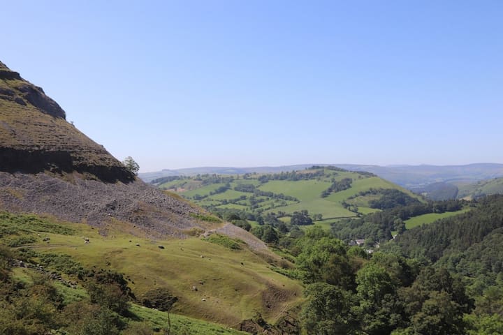
The Monmouthshire and Brecon Canal (Welsh: Camlas Sir Fynwy a Brycheiniog) is a small network of canals in South Wales. For most of its currently (2018) navigable 35-mile (56 km) length[1] it runs through the Brecon Beacons National Park, and its present rural character and tranquillity belies its original purpose as an industrial corridor for coal and iron, which were brought to the canal by a network of tramways and/or railroads, many of which were built and owned by the canal company.
30 recommandé par les habitants
Canaux du bassin de Brecon
The Monmouthshire and Brecon Canal (Welsh: Camlas Sir Fynwy a Brycheiniog) is a small network of canals in South Wales. For most of its currently (2018) navigable 35-mile (56 km) length[1] it runs through the Brecon Beacons National Park, and its present rural character and tranquillity belies its original purpose as an industrial corridor for coal and iron, which were brought to the canal by a network of tramways and/or railroads, many of which were built and owned by the canal company.
The Black Mountains (Welsh: Y Mynydd Du) are a group of hills spread across parts of Powys and Monmouthshire in southeast Wales, and extending across the England–Wales border into Herefordshire. They are the easternmost of the four ranges of hills that comprise the Brecon Beacons National Park, and are frequently confused with the westernmost, which is known as the Black Mountain. The Black Mountains may be roughly defined as those hills contained within a triangle defined by the towns of Abergavenny in the southeast, Hay-on-Wye in the north and the village of Llangors in the west. Other gateway towns to the Black Mountains include Talgarth and Crickhowell. The range of hills is well known to walkers and ramblers for the ease of access and views from the many ridge trails, such as that on the Black Hill (Herefordshire) at the eastern edge of the massif.
94 recommandé par les habitants
Sugar Loaf
The Black Mountains (Welsh: Y Mynydd Du) are a group of hills spread across parts of Powys and Monmouthshire in southeast Wales, and extending across the England–Wales border into Herefordshire. They are the easternmost of the four ranges of hills that comprise the Brecon Beacons National Park, and are frequently confused with the westernmost, which is known as the Black Mountain. The Black Mountains may be roughly defined as those hills contained within a triangle defined by the towns of Abergavenny in the southeast, Hay-on-Wye in the north and the village of Llangors in the west. Other gateway towns to the Black Mountains include Talgarth and Crickhowell. The range of hills is well known to walkers and ramblers for the ease of access and views from the many ridge trails, such as that on the Black Hill (Herefordshire) at the eastern edge of the massif.
Offa's Dyke Path (Welsh: Llwybr Clawdd Offa) is a long-distance footpath broadly following the Wales–England border. Officially opened on 10 July 1971, by Lord Hunt, it is one of Britain's National Trails and draws walkers from throughout the world. About 60 miles (97 km) of the 177-mile (285 km) route either follows, or keeps close company with, the remnants of Offa's Dyke, an earthwork, most of which was probably constructed in the late 8th century on the orders of King Offa of Mercia.[1]O
8 recommandé par les habitants
Offa's Dyke Path
Offa's Dyke PathOffa's Dyke Path (Welsh: Llwybr Clawdd Offa) is a long-distance footpath broadly following the Wales–England border. Officially opened on 10 July 1971, by Lord Hunt, it is one of Britain's National Trails and draws walkers from throughout the world. About 60 miles (97 km) of the 177-mile (285 km) route either follows, or keeps close company with, the remnants of Offa's Dyke, an earthwork, most of which was probably constructed in the late 8th century on the orders of King Offa of Mercia.[1]O
Historical
The Aberfan disaster was the catastrophic collapse of a colliery spoil tip on 21 October 1966. The tip had been created on a mountain slope above the Welsh village of Aberfan, near Merthyr Tydfil, and overlaid a natural spring. A period of heavy rain led to a build-up of water within the tip which caused it to suddenly slide downhill as a slurry, killing 116 children and 28 adults as it engulfed Pantglas Junior School and other buildings. The tip was the responsibility of the National Coal Board (NCB), and the subsequent inquiry placed the blame for the disaster on the organisation and nine named employees.
Tintern Abbey (and walks) was founded on 9 May 1131 by Walter de Clare, Lord of Chepstow. It is situated adjacent to the village of Tintern in Monmouthshire, on the Welsh bank of the River Wye, which at this location forms the border between Monmouthshire in Wales and Gloucestershire in England. It was the first Cistercian foundation in Wales, and only the second in Britain (after Waverley Abbey).
Tintern Abbey and Devils Pulpit is a 8.5 kilometer loop trail located near Chepstow, Monmouthshire, Wales that features a river and is good for all skill levels. The trail is primarily used for hiking, walking, nature trips, and bird watching.
167 recommandé par les habitants
Abbaye de Tintern / Abaty Tyndryn
Tintern Abbey (and walks) was founded on 9 May 1131 by Walter de Clare, Lord of Chepstow. It is situated adjacent to the village of Tintern in Monmouthshire, on the Welsh bank of the River Wye, which at this location forms the border between Monmouthshire in Wales and Gloucestershire in England. It was the first Cistercian foundation in Wales, and only the second in Britain (after Waverley Abbey).
Tintern Abbey and Devils Pulpit is a 8.5 kilometer loop trail located near Chepstow, Monmouthshire, Wales that features a river and is good for all skill levels. The trail is primarily used for hiking, walking, nature trips, and bird watching.
2000 YEARS OF HISTORY IN THE HEART OF THE CITY
Cardiff Castle is one of Wales’ leading heritage attractions and a site of international significance. Located at the heart of the capital, within beautiful parklands, the Castle has nearly 2,000 years of history just waiting to be explored.
It all started in the 1st century AD by the Romans who built the first in a series of forts. In the 11th century, the Normans constructed the Keep that still dominates the Castle Green to this day. The medieval Lords of Glamorgan began work on the House during the 15th century.
The Bute family left their mark on the entire city in the 19th century, they also transformed the House into the opulent Victorian Gothic home it is today. During World War II the walls which surround the Castle were used as air raid shelters; a place of safety for thousands of Cardiff citizens. A reconstruction of the shelters has been opened for visitors to explore.
376 recommandé par les habitants
Château de Cardiff
Castle St
2000 YEARS OF HISTORY IN THE HEART OF THE CITY
Cardiff Castle is one of Wales’ leading heritage attractions and a site of international significance. Located at the heart of the capital, within beautiful parklands, the Castle has nearly 2,000 years of history just waiting to be explored.
It all started in the 1st century AD by the Romans who built the first in a series of forts. In the 11th century, the Normans constructed the Keep that still dominates the Castle Green to this day. The medieval Lords of Glamorgan began work on the House during the 15th century.
The Bute family left their mark on the entire city in the 19th century, they also transformed the House into the opulent Victorian Gothic home it is today. During World War II the walls which surround the Castle were used as air raid shelters; a place of safety for thousands of Cardiff citizens. A reconstruction of the shelters has been opened for visitors to explore.