
Hiking Trails INFO
- - HIKING INFO NEARBY TO OUR LINCOLN AIRBNB - -
Distance from our Lincoln Airbnb home = 11 min (8.1 miles)
--------------
2.7mi
DIFFICULT
Lincoln, NH
Need to Know
It's a large parking lot but if fills up quickly particularly in the summer and fall. You cannot park along the interstate.
Description
Old Bridle Trail begins from the center of the Franconia Notch Parking area. This route will take you all the way up to the Greenleaf Hut. When combined with several other trail in the area it makes the incredible Franconia Ridge Loop.
It's a well worn trail and easy to follow but is only marked occasionally with worn yellow blazes. You'll start through the woods and about 0.2 miles from the trailhead you travel parallel to Walker Brook for a bit before reaching a fork for the Falling Waters Trail. Continue to the left for Old Bridle or the right and across the bridge for Falling Waters. You'll continue parallel to Walker Brook for a short distance before curving off to the left.
The trail continues mostly flat until about 0.55 from the trailhead where it makes a sharp tight turn and the real climb begins. You'll continue to climb for the next mile or so as the terrain gets a bit rougher and the rocks get larger. Might reach an occasional viewpoint or two but at least to start they are mostly blocked.
At about 1.35 you begin the final ascent to the ridge that will take you up to Greenleaf hut. You'll reach the first of a series of viewpoints looking towards Franconia Ridge and back down through Franconia Notch at about 1.55 miles from the trailhead. From about 1.55 to 1.85 you'll have frequent excellent view of the area as you climb along a rocky, narrow trail with lower tree cover.
You'll have one more steep climb from about 2.15 miles through to 2.5 miles. It'll be rocky and challenging but as you get higher, especially around 2.3 miles the views only improve until you can see the ridge you just hiked up, Cannon Mountain across the notch, and tons of other peaks in the area.
Finally the trail will mostly flatten out from 2.45 miles until you reach Greenleaf hut after approximately 2.75 miles total.
Old Bridle Path Trailhead
Distance from our Lincoln Airbnb home = 11 min (8.1 miles)
--------------
2.7mi
DIFFICULT
Lincoln, NH
Need to Know
It's a large parking lot but if fills up quickly particularly in the summer and fall. You cannot park along the interstate.
Description
Old Bridle Trail begins from the center of the Franconia Notch Parking area. This route will take you all the way up to the Greenleaf Hut. When combined with several other trail in the area it makes the incredible Franconia Ridge Loop.
It's a well worn trail and easy to follow but is only marked occasionally with worn yellow blazes. You'll start through the woods and about 0.2 miles from the trailhead you travel parallel to Walker Brook for a bit before reaching a fork for the Falling Waters Trail. Continue to the left for Old Bridle or the right and across the bridge for Falling Waters. You'll continue parallel to Walker Brook for a short distance before curving off to the left.
The trail continues mostly flat until about 0.55 from the trailhead where it makes a sharp tight turn and the real climb begins. You'll continue to climb for the next mile or so as the terrain gets a bit rougher and the rocks get larger. Might reach an occasional viewpoint or two but at least to start they are mostly blocked.
At about 1.35 you begin the final ascent to the ridge that will take you up to Greenleaf hut. You'll reach the first of a series of viewpoints looking towards Franconia Ridge and back down through Franconia Notch at about 1.55 miles from the trailhead. From about 1.55 to 1.85 you'll have frequent excellent view of the area as you climb along a rocky, narrow trail with lower tree cover.
You'll have one more steep climb from about 2.15 miles through to 2.5 miles. It'll be rocky and challenging but as you get higher, especially around 2.3 miles the views only improve until you can see the ridge you just hiked up, Cannon Mountain across the notch, and tons of other peaks in the area.
Finally the trail will mostly flatten out from 2.45 miles until you reach Greenleaf hut after approximately 2.75 miles total.
Distance from our Lincoln Airbnb home = 20 min (13.8 miles)
-------
Basin Cascades
1.2mi
INTERMEDIATE/DIFFICULT
6 recommandé par les habitants
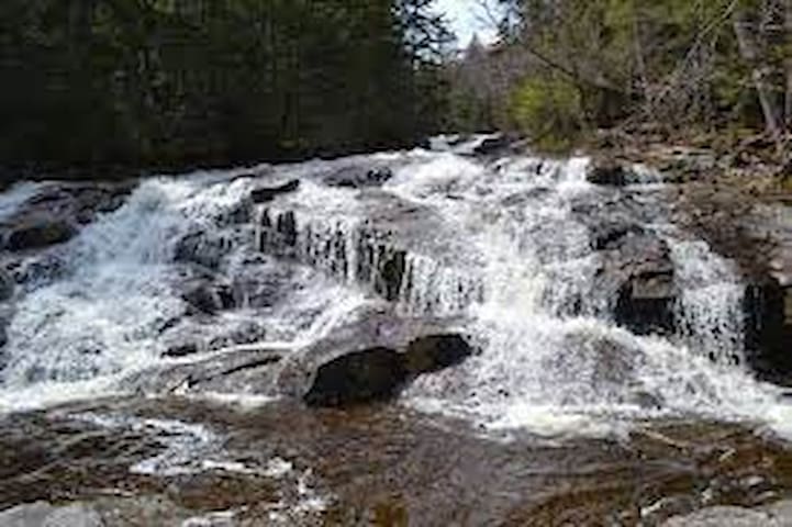
Basin Cascade Trail
Basin Cascade TrailDistance from our Lincoln Airbnb home = 20 min (13.8 miles)
-------
Basin Cascades
1.2mi
INTERMEDIATE/DIFFICULT
Distance from our Lincoln Airbnb home = 7 min (5.0 miles)
Mount Pemigewasset Trail
1.7mi
INTERMEDIATE
Lincoln, NH
Dogs Unknown
Features
Birding • Fall Colors • Views • Wildlife
Description
This trail starts by branching off of the Franconia Notch State Park Recreational Trail. It soon crosses under Route 3 and a footbridge, then begins ascending in earnest to its junction with the Indian Head Trail. Along this portion of the trail, be sure to take your time as you slog up the trail's steep, relentless grades.
From the Indian Head Trail junction, follow the Mount Pemigewasset Trail to the summit. Take care on the ledges when ice is present. For more information, check out the AMC's White Mountain Guide.
Mt. Pemigewasset Trailhead
Distance from our Lincoln Airbnb home = 7 min (5.0 miles)
Mount Pemigewasset Trail
1.7mi
INTERMEDIATE
Lincoln, NH
Dogs Unknown
Features
Birding • Fall Colors • Views • Wildlife
Description
This trail starts by branching off of the Franconia Notch State Park Recreational Trail. It soon crosses under Route 3 and a footbridge, then begins ascending in earnest to its junction with the Indian Head Trail. Along this portion of the trail, be sure to take your time as you slog up the trail's steep, relentless grades.
From the Indian Head Trail junction, follow the Mount Pemigewasset Trail to the summit. Take care on the ledges when ice is present. For more information, check out the AMC's White Mountain Guide.
Distance from our Lincoln Airbnb home = 8 min (5.0 miles)
Flume Gorge Trail
1.8mi - INTERMEDIATE
Lincoln, NH
88 recommandé par les habitants
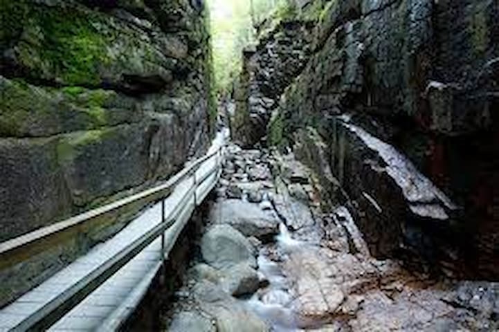
The Flume
Distance from our Lincoln Airbnb home = 8 min (5.0 miles)
Flume Gorge Trail
1.8mi - INTERMEDIATE
Lincoln, NH
Distance from our Lincoln Airbnb home = 10 min (8.1 miles)
Falling Waters Trail
2.8mi
DIFFICULT
Lincoln, NH
Dogs Unknown
Features
Fall Colors • River/Creek • Waterfall
Description
Starting east of the Franconia Notch Parkway, follow Old Bridle Path. The trail splits at 0.2 miles and turns right to stay on Falling Water Trail.
Falling Waters Trail
Falling Waters TrailDistance from our Lincoln Airbnb home = 10 min (8.1 miles)
Falling Waters Trail
2.8mi
DIFFICULT
Lincoln, NH
Dogs Unknown
Features
Fall Colors • River/Creek • Waterfall
Description
Starting east of the Franconia Notch Parkway, follow Old Bridle Path. The trail splits at 0.2 miles and turns right to stay on Falling Water Trail.
Distance from our Lincoln Airbnb home = 8 min (4.8 miles)
Lincoln Woods Trail
3.0mi
EASY
Lincoln, NH
Dogs
Leashed
Features
Fall Colors • River/Creek • Views
Description
This trail is a main route into the headwaters of the East Branch of the Pemigewasset River and leads into one of the largest roadless areas in the eastern United States known as the Pemigewasset Wilderness.
Backpackers, hikers, fishermen, and mountain bikers all share this very popular multiple use trail. Motorized vehicles are prohibited. Summer is the heaviest use season, but with increased popularity of cross country skiing, the trail is also extensively used in winter. The fall season provides an excellent opportunity to enjoy hiking trails with cooler temperatures, fewer bugs, and fall foliage colors.
The Lincoln Woods Trail comes close to the river at 1.7 miles providing a nice view of Mt. Bond, and then crosses Birch Island Brook on a foot bridge at 1.8 miles. At 2.8 miles, the former Franconia Brook Campsite, now a Forest Protection Area, remains closed for health and safety reasons. An interim camping area with 24 sites has been established across the river on the northern end of the East Side Trail (truck service road). Camping in the Franconia Brook East - no fee is charged.
Past the former campsite is a stone wall and a narrow 75-foot bridge that crosses Franconia Brook. At the stone wall, a path veers left, leaving the trail, to follow the brook upstream 0.4 mile to scenic Franconia Falls, a large rock outcrop about an acre in size with cascading water. Franconia Falls restrooms have been closed. Unacceptable sanitary conditions and improper human waste disposal have caused general deterioration of this area. A sanitation kit is available for a nominal fee at the Visitor Center.
After crossing the bridge over Franconia Falls, the Lincoln Woods Trail ends and becomes the Wilderness Trail as it enters the Pemigewasset Wilderness.
Lincoln Woods
This very large parking area has many ammenities, including restrooms, potable water, interpretive panels, trash receptacles and a cabin. Short nature trails between a suspension bridge and a pedestrian bridge alongside Rte. 112, both spanning the west branch of the Pemigewasset river, afford an accessible self-guided loop walk through the area.
Lincoln Woods trailhead is considered the gateway to the Pemigewasset Wilderness, the largest in the northeast. Popular backcountry destinations include the Bondcliffs and Thirteen Falls Campsite, but in warm weather great numbers of people visit scenic Franconia Falls. From the trailhead, Eastside and Lincoln Woods trails travel up either side of the river, and intersect with many trails, notably Osseo, Bondcliff, Wilderness, and Cedar Brook.
11 recommandé par les habitants
Lincoln Woods Trailhead
Kancamagus HighwayDistance from our Lincoln Airbnb home = 8 min (4.8 miles)
Lincoln Woods Trail
3.0mi
EASY
Lincoln, NH
Dogs
Leashed
Features
Fall Colors • River/Creek • Views
Description
This trail is a main route into the headwaters of the East Branch of the Pemigewasset River and leads into one of the largest roadless areas in the eastern United States known as the Pemigewasset Wilderness.
Backpackers, hikers, fishermen, and mountain bikers all share this very popular multiple use trail. Motorized vehicles are prohibited. Summer is the heaviest use season, but with increased popularity of cross country skiing, the trail is also extensively used in winter. The fall season provides an excellent opportunity to enjoy hiking trails with cooler temperatures, fewer bugs, and fall foliage colors.
The Lincoln Woods Trail comes close to the river at 1.7 miles providing a nice view of Mt. Bond, and then crosses Birch Island Brook on a foot bridge at 1.8 miles. At 2.8 miles, the former Franconia Brook Campsite, now a Forest Protection Area, remains closed for health and safety reasons. An interim camping area with 24 sites has been established across the river on the northern end of the East Side Trail (truck service road). Camping in the Franconia Brook East - no fee is charged.
Past the former campsite is a stone wall and a narrow 75-foot bridge that crosses Franconia Brook. At the stone wall, a path veers left, leaving the trail, to follow the brook upstream 0.4 mile to scenic Franconia Falls, a large rock outcrop about an acre in size with cascading water. Franconia Falls restrooms have been closed. Unacceptable sanitary conditions and improper human waste disposal have caused general deterioration of this area. A sanitation kit is available for a nominal fee at the Visitor Center.
After crossing the bridge over Franconia Falls, the Lincoln Woods Trail ends and becomes the Wilderness Trail as it enters the Pemigewasset Wilderness.
Lincoln Woods
This very large parking area has many ammenities, including restrooms, potable water, interpretive panels, trash receptacles and a cabin. Short nature trails between a suspension bridge and a pedestrian bridge alongside Rte. 112, both spanning the west branch of the Pemigewasset river, afford an accessible self-guided loop walk through the area.
Lincoln Woods trailhead is considered the gateway to the Pemigewasset Wilderness, the largest in the northeast. Popular backcountry destinations include the Bondcliffs and Thirteen Falls Campsite, but in warm weather great numbers of people visit scenic Franconia Falls. From the trailhead, Eastside and Lincoln Woods trails travel up either side of the river, and intersect with many trails, notably Osseo, Bondcliff, Wilderness, and Cedar Brook.
Distance from our Lincoln Airbnb home = 7 min (5.8 miles)
Osseo
3.9mi
INTERMEDIATE/DIFFICULT
Lincoln, NH
Osseo Road
Osseo RoadDistance from our Lincoln Airbnb home = 7 min (5.8 miles)
Osseo
3.9mi
INTERMEDIATE/DIFFICULT
Lincoln, NH
Distance from our Lincoln Airbnb home = 12 min (10.2 miles)
Greenleaf
3.2mi
DIFFICULT
Franconia, NH
Greenleaf Trail
Greenleaf TrailDistance from our Lincoln Airbnb home = 12 min (10.2 miles)
Greenleaf
3.2mi
DIFFICULT
Franconia, NH
Distance from our Lincoln Airbnb home = 8 min (12.6 miles)
Lonesome Lake Hut Trail
0.3mi
EASY/INTERMEDIATE
Franconia, NH
AMC Lonesome Lake Hut
Distance from our Lincoln Airbnb home = 8 min (12.6 miles)
Lonesome Lake Hut Trail
0.3mi
EASY/INTERMEDIATE
Franconia, NH
Distance from our Lincoln Airbnb home = 16 min (11.6 miles)
Artists Bluff Trail
0.8mi
INTERMEDIATE/DIFFICULT
Franconia, NH
Dogs Unknown
Description
All of the trails in this area, including this one, are blazed red. The trail includes some moderate inclines for the first two thirds of the route. Shortly after beginning on the trail it comes to a junction with the Bald Mountain Spur. It then continues upward and onward to Artist's Bluff Spur.
Both of these spurs are short and offer very rewarding views. After passing Artist's Bluff the trail descends pretty steeply. Throughout this trail, especially on the way down, there are some minor exposed roots and rocks. However, this trail is generally pretty well taken care of. The trail ends on Profile Road across from Echo Lake.
41 recommandé par les habitants
Artist's Bluff Loop
2750 Profile RdDistance from our Lincoln Airbnb home = 16 min (11.6 miles)
Artists Bluff Trail
0.8mi
INTERMEDIATE/DIFFICULT
Franconia, NH
Dogs Unknown
Description
All of the trails in this area, including this one, are blazed red. The trail includes some moderate inclines for the first two thirds of the route. Shortly after beginning on the trail it comes to a junction with the Bald Mountain Spur. It then continues upward and onward to Artist's Bluff Spur.
Both of these spurs are short and offer very rewarding views. After passing Artist's Bluff the trail descends pretty steeply. Throughout this trail, especially on the way down, there are some minor exposed roots and rocks. However, this trail is generally pretty well taken care of. The trail ends on Profile Road across from Echo Lake.
Distance from our Lincoln Airbnb home = 8 min (5.8 miles)
Cascade Brook Trail
3.0mi
INTERMEDIATE
Lincoln, NH
Dogs Unknown
Features
Fall Colors • Lake • River/Creek
Description
The trail crosses under the parkway and heads northwest, crossing the Whitehouse Brook and then the Cascade Brook. The junction of the Basin Cascades Trail is just before the crossing and there is a small waterfall just south of the Basin Cascades Trail. The trail continues after crossing the Cascade Brook, which is difficult to manage in high water. The trail follows the brook until the junction of the Kinsman Pond Trail on the left, where it leaves the Cascade Brook and gently climbs to Lonesome Lake. The AMC Lonsesome Lake Hut and Fishin' Jimmy Trail are on the left after the trail ends at the lake.
Cascade Brook Trail
Cascade Brook TrailDistance from our Lincoln Airbnb home = 8 min (5.8 miles)
Cascade Brook Trail
3.0mi
INTERMEDIATE
Lincoln, NH
Dogs Unknown
Features
Fall Colors • Lake • River/Creek
Description
The trail crosses under the parkway and heads northwest, crossing the Whitehouse Brook and then the Cascade Brook. The junction of the Basin Cascades Trail is just before the crossing and there is a small waterfall just south of the Basin Cascades Trail. The trail continues after crossing the Cascade Brook, which is difficult to manage in high water. The trail follows the brook until the junction of the Kinsman Pond Trail on the left, where it leaves the Cascade Brook and gently climbs to Lonesome Lake. The AMC Lonsesome Lake Hut and Fishin' Jimmy Trail are on the left after the trail ends at the lake.
Distance from our Lincoln Airbnb home = 9 min (4.7 miles)
14 Franconia Falls Trail
0.5mi
INTERMEDIATE
Lincoln, NH
Franconia Falls Trail
Franconia Falls TrailDistance from our Lincoln Airbnb home = 9 min (4.7 miles)
14 Franconia Falls Trail
0.5mi
INTERMEDIATE
Lincoln, NH
Distance from our Lincoln Airbnb home = 15 min (12.5 miles)
Hi-Cannon Trail
1.6mi
DIFFICULT
Lincoln, NH
Dogs Leashed
Features Fall Colors • Views
Description
Following the Lonesome Lake Trail from Lafayette Place Campground, the Hi-Cannon Trail is the most direct route up the east slope of Cannon Mountain. Known for its relentless grades, the trail climbs just under 2000 feet in a mile and a half. The first 0.75 miles of this trail contain many twists and turns through a densely wooded area.
After about 1 mile of climbing a winding, narrow, and wooded pathway, this trail turns sharply right to climb a wooden ladder up and over a small rocky cliff. The trail then climbs at a steep grade for another quarter mile before evening out at the junction with the Kinsman Ridge Trail just 0.4 miles from the summit of Cannon Mountain.
Hi-Cannon Trail
Hi-Cannon TrailDistance from our Lincoln Airbnb home = 15 min (12.5 miles)
Hi-Cannon Trail
1.6mi
DIFFICULT
Lincoln, NH
Dogs Leashed
Features Fall Colors • Views
Description
Following the Lonesome Lake Trail from Lafayette Place Campground, the Hi-Cannon Trail is the most direct route up the east slope of Cannon Mountain. Known for its relentless grades, the trail climbs just under 2000 feet in a mile and a half. The first 0.75 miles of this trail contain many twists and turns through a densely wooded area.
After about 1 mile of climbing a winding, narrow, and wooded pathway, this trail turns sharply right to climb a wooden ladder up and over a small rocky cliff. The trail then climbs at a steep grade for another quarter mile before evening out at the junction with the Kinsman Ridge Trail just 0.4 miles from the summit of Cannon Mountain.
Distance from our Lincoln Airbnb home = 23 min (16.4 miles)
Coppermine
2.1mi
INTERMEDIATE
Franconia, NH
Dogs Off-leash
Features River/Creek • Swimming • Waterfall
Description
The trail is around 2.5 miles in length when starting from the parking area and has an elevation gain of 1100 ft. The trailhead is on Beechwood Lane, and you have to park there and hike down the road for 0.3 miles until you get to Coppermine Rd. At 1.0 mile, the trail joins Coppermine Brook where a side path descends to a cascade.
At 2.3 miles you cross the brook on a bridge and quickly hit the Coppermine shelter. Just beyond the shelter is the first viewpoint of Bridal Veil Falls from a lower pool. If you want to get a good photo of the falls like the one shown on this website you need to carefully pick your way up the left-hand side of the falls area. Be careful though the rocks at the upper pool will be slick, but it is worth it to catch the spray off of the falls.
Coppermine Shelter
Coppermine RoadDistance from our Lincoln Airbnb home = 23 min (16.4 miles)
Coppermine
2.1mi
INTERMEDIATE
Franconia, NH
Dogs Off-leash
Features River/Creek • Swimming • Waterfall
Description
The trail is around 2.5 miles in length when starting from the parking area and has an elevation gain of 1100 ft. The trailhead is on Beechwood Lane, and you have to park there and hike down the road for 0.3 miles until you get to Coppermine Rd. At 1.0 mile, the trail joins Coppermine Brook where a side path descends to a cascade.
At 2.3 miles you cross the brook on a bridge and quickly hit the Coppermine shelter. Just beyond the shelter is the first viewpoint of Bridal Veil Falls from a lower pool. If you want to get a good photo of the falls like the one shown on this website you need to carefully pick your way up the left-hand side of the falls area. Be careful though the rocks at the upper pool will be slick, but it is worth it to catch the spray off of the falls.
Distance from our Lincoln Airbnb home = 7 min (5.9 miles)
Flume Slide Trail
3.0mi
DIFFICULT
Lincoln, NH
Dogs Leashed
Features River/Creek • Views • Wildlife
Description
This trail actually connects with Liberty Spring about 0.6 miles from the Liberty Spring Trailhead. The first two miles contain very little elevation gain and are a nice warmup. There are a few stream crossings that could be tricky based on water level, but nothing crazy. The final half mile is almost entirely scrambling/climbing. It's a difficult stretch that can be dicey in spots, especially if wet, but also can provide excellent views. Once connected to the Franconia Ridge Trail, it's a short hike to the top of Mount Flume. If starting at the Liberty Spring Trailhead, this trail makes for a nice loop that involves summiting Mount Flume and Mount Liberty and descending back down Liberty Spring.
Flume Slide Trail
Flume Slide Trail Distance from our Lincoln Airbnb home = 7 min (5.9 miles)
Flume Slide Trail
3.0mi
DIFFICULT
Lincoln, NH
Dogs Leashed
Features River/Creek • Views • Wildlife
Description
This trail actually connects with Liberty Spring about 0.6 miles from the Liberty Spring Trailhead. The first two miles contain very little elevation gain and are a nice warmup. There are a few stream crossings that could be tricky based on water level, but nothing crazy. The final half mile is almost entirely scrambling/climbing. It's a difficult stretch that can be dicey in spots, especially if wet, but also can provide excellent views. Once connected to the Franconia Ridge Trail, it's a short hike to the top of Mount Flume. If starting at the Liberty Spring Trailhead, this trail makes for a nice loop that involves summiting Mount Flume and Mount Liberty and descending back down Liberty Spring.
Distance from our Lincoln Airbnb home = 12 min (7.2 miles)
18 Kinsman Ridge Trail
15.1mi
DIFFICULT
Lincoln, NH
Dogs Leashed
Features
Fall Colors • Lake • River/Creek • Views
During the winter months, the section of the Kinsman Ridge Trail between Kinsman Pond and Cannon Mountain can be quite difficult to follow due to few trail blazes and many downed trees.
Description
A good portion of the Kinsman Ridge Trail is along the Appalachian Trail. Climbing moderately from the Kancamagus Highway, you reach the small peak of Mount Wolf (3500 ft) after about 4 miles. This first part of the trail brings moderate-to-difficult grades ranging from 2-30%. From the top of Mount Wolf, prepare to descend just under 1000 feet through beautiful dense woodlands.
Roughly 2.8 miles later, the trail reaches the Eliza Brook Shelter. After reaching the shelter, get ready for a shockingly steep ascent up to the South Peak of Kinsman Mountain. The South Peak is exposed and has great views of the Franconia Ridge, Moosilauke, and Vermont on clear days.
Following the trail down the side of the South Peak, you enter a wooded area that winds along the side of the North Peak of Kinsman Mountain, which is roughly 65 feet smaller than its sister. The ascent up to the North Peak is moderately steep, both up and then down toward the Kinsman Pond Shelter. From the top of the North Peak, there is a pronounced rock ledge that faces Franconia Ridge, offering an excellent view of Lafayette, Lincoln, Liberty, and Flume.
After descending and reaching the trail juncture, the Appalachian Trail continues along the Fishin' Jimmy Trail while the Kinsman Ridge Trail continues north toward Cannon Mountain. This section of the trail is densely wooded at times, and in the winter it's filled with snow and tough patches. The traverse begins with a steep ascent up to a 3,812 foot nameless peak, which is highly windblown and contains many downed trees. The trail then descends steady grades, dropping roughly 300 vertical feet and continues in a narrow fashion.
The Kinsman Ridge Trail continues through more wooded areas and traverses across the Cannon Balls toward Cannon Mountain. The trail reaches a low point at 3288 feet before continuing up a very steep grade until merging with the Lonesome Lake Trail at 3,750 feet. The trail then drops 300 vertical feet to the base of Cannon Mountain, where it climbs at extreme grades (reaching 60% at times) until hitting the juncture with the Hi-Cannon Trail.
From here the summit of Cannon Mountain is just 0.4 miles, at which point you can climb a tower that offers you an amazing, 360-degree view of the surrounding area. Just below the tower is the summit lift for Cannon Mountain Ski Area and the Aerial Tramway Station.
From here, the trail descends on the other side of Cannon Mountain, along the path for the Aerial Tramway, to reach the southbound side of I-93 and the trail's end.
Kinsman Ridge Trailhead
260 Tramway DriveDistance from our Lincoln Airbnb home = 12 min (7.2 miles)
18 Kinsman Ridge Trail
15.1mi
DIFFICULT
Lincoln, NH
Dogs Leashed
Features
Fall Colors • Lake • River/Creek • Views
During the winter months, the section of the Kinsman Ridge Trail between Kinsman Pond and Cannon Mountain can be quite difficult to follow due to few trail blazes and many downed trees.
Description
A good portion of the Kinsman Ridge Trail is along the Appalachian Trail. Climbing moderately from the Kancamagus Highway, you reach the small peak of Mount Wolf (3500 ft) after about 4 miles. This first part of the trail brings moderate-to-difficult grades ranging from 2-30%. From the top of Mount Wolf, prepare to descend just under 1000 feet through beautiful dense woodlands.
Roughly 2.8 miles later, the trail reaches the Eliza Brook Shelter. After reaching the shelter, get ready for a shockingly steep ascent up to the South Peak of Kinsman Mountain. The South Peak is exposed and has great views of the Franconia Ridge, Moosilauke, and Vermont on clear days.
Following the trail down the side of the South Peak, you enter a wooded area that winds along the side of the North Peak of Kinsman Mountain, which is roughly 65 feet smaller than its sister. The ascent up to the North Peak is moderately steep, both up and then down toward the Kinsman Pond Shelter. From the top of the North Peak, there is a pronounced rock ledge that faces Franconia Ridge, offering an excellent view of Lafayette, Lincoln, Liberty, and Flume.
After descending and reaching the trail juncture, the Appalachian Trail continues along the Fishin' Jimmy Trail while the Kinsman Ridge Trail continues north toward Cannon Mountain. This section of the trail is densely wooded at times, and in the winter it's filled with snow and tough patches. The traverse begins with a steep ascent up to a 3,812 foot nameless peak, which is highly windblown and contains many downed trees. The trail then descends steady grades, dropping roughly 300 vertical feet and continues in a narrow fashion.
The Kinsman Ridge Trail continues through more wooded areas and traverses across the Cannon Balls toward Cannon Mountain. The trail reaches a low point at 3288 feet before continuing up a very steep grade until merging with the Lonesome Lake Trail at 3,750 feet. The trail then drops 300 vertical feet to the base of Cannon Mountain, where it climbs at extreme grades (reaching 60% at times) until hitting the juncture with the Hi-Cannon Trail.
From here the summit of Cannon Mountain is just 0.4 miles, at which point you can climb a tower that offers you an amazing, 360-degree view of the surrounding area. Just below the tower is the summit lift for Cannon Mountain Ski Area and the Aerial Tramway Station.
From here, the trail descends on the other side of Cannon Mountain, along the path for the Aerial Tramway, to reach the southbound side of I-93 and the trail's end.
Distance from our Lincoln Airbnb home = 16 min (12.7 miles)
Lonesome Lake Trail
2.2mi
INTERMEDIATE/DIFFICULT
Lincoln, NH
Lonesome Lake Loop
Lonesome Lake Loop Distance from our Lincoln Airbnb home = 16 min (12.7 miles)
Lonesome Lake Trail
2.2mi
INTERMEDIATE/DIFFICULT
Lincoln, NH
Distance from our Lincoln Airbnb home = 23 min (17.2 miles)
Mt. Kinsman
3.5mi
DIFFICULT
Franconia, NH
Mt. Kinsman Trail Trail Head
1671 Easton RoadDistance from our Lincoln Airbnb home = 23 min (17.2 miles)
Mt. Kinsman
3.5mi
DIFFICULT
Franconia, NH
Distance from our Lincoln Airbnb home = 6 min (3.7 miles)
Indian Head Trail
1.7mi
INTERMEDIATE/DIFFICULT
Lincoln, NH
Dogs Unknown
Features Birding • Fall Colors • River/Creek • Views • Wildlife
Description
From the start, the trail traverses moderately through an open field before passing beneath the parkway. Shortly thereafter, enjoy a small cascade with rock walls before the trail begins to increase in grade. In another mile, the trail becomes much steeper and rockier, so you'll want to watch your footing when snow and ice are present.
After much exertion, the trail reaches the junction with Mount Pemigewasset Trail, which you'll need to follow to reach the summit of Mount Pemigewasset/Indian Head. The trail comes to an open view and skirts around the ledges to the summit. This area can be dangerous when ice is present, so it's a good idea to bring traction aids if you're attempting this trail in the winter.
If you take Mount Pemigewasset Trail on the way back down from the junction, it will bring you out to the trails at the Flume.
We have detailed three different routes, and the description in this article focuses mainly on the loop trail:
Indian Head Trail (3.7mi & 1,535ft)
Indian Head Trail
664 US-3, Lincoln, NH 03251
Mt Pemigewasset (Indian Head)
• 4-star hike
• 3.5 to 4.6 mile options
• Medium difficulty | Gain 1,250 to 1,535 feet
• White Mountains Region | Lincoln NH
Mount Pemigewasset Trail (3.5mi & 1,250ft) - An out-and-back journey commencing at either the Flume Gorge Visitor Center or the Liberty Springs Parking Lot. This is the easiest route, but doesn’t give you the profile view of the Indian Head.
Mt Pemigewasset Loop (4.6mi & 1,500ft) - We chose to get the most out of this mountain by combining the two trails into a single counter-clockwise loop by including a snowmobile trail that connects the trailheads together at the bottom of the valley.
Indian Head Trail
664 US-3Distance from our Lincoln Airbnb home = 6 min (3.7 miles)
Indian Head Trail
1.7mi
INTERMEDIATE/DIFFICULT
Lincoln, NH
Dogs Unknown
Features Birding • Fall Colors • River/Creek • Views • Wildlife
Description
From the start, the trail traverses moderately through an open field before passing beneath the parkway. Shortly thereafter, enjoy a small cascade with rock walls before the trail begins to increase in grade. In another mile, the trail becomes much steeper and rockier, so you'll want to watch your footing when snow and ice are present.
After much exertion, the trail reaches the junction with Mount Pemigewasset Trail, which you'll need to follow to reach the summit of Mount Pemigewasset/Indian Head. The trail comes to an open view and skirts around the ledges to the summit. This area can be dangerous when ice is present, so it's a good idea to bring traction aids if you're attempting this trail in the winter.
If you take Mount Pemigewasset Trail on the way back down from the junction, it will bring you out to the trails at the Flume.
We have detailed three different routes, and the description in this article focuses mainly on the loop trail:
Indian Head Trail (3.7mi & 1,535ft)
Indian Head Trail
664 US-3, Lincoln, NH 03251
Mt Pemigewasset (Indian Head)
• 4-star hike
• 3.5 to 4.6 mile options
• Medium difficulty | Gain 1,250 to 1,535 feet
• White Mountains Region | Lincoln NH
Mount Pemigewasset Trail (3.5mi & 1,250ft) - An out-and-back journey commencing at either the Flume Gorge Visitor Center or the Liberty Springs Parking Lot. This is the easiest route, but doesn’t give you the profile view of the Indian Head.
Mt Pemigewasset Loop (4.6mi & 1,500ft) - We chose to get the most out of this mountain by combining the two trails into a single counter-clockwise loop by including a snowmobile trail that connects the trailheads together at the bottom of the valley.
Distance from our Lincoln Airbnb home = 8 min (5.8 miles)
Liberty Spring
2.7mi
DIFFICULT
Lincoln, NH
Liberty Springs Trail
Liberty Springs TrailDistance from our Lincoln Airbnb home = 8 min (5.8 miles)
Liberty Spring
2.7mi
DIFFICULT
Lincoln, NH
Distance from our Lincoln Airbnb home = 8 min (4.9 miles)
East Side Trail
Lincoln NH
5.3mi
EASY/INTERMEDIATE
Lincoln, NH
Dogs Off-leash
Description
The primary trail access is the Lincoln Woods Visitor Center at the southern terminus of the trail. The trail starts at the rear of the visitor center, in the back of the parking lot. You can also take the pedestrian bridge over the river to access the Lincoln Woods Trail.
The first 2.5 miles of the trail, reaching the Franconia Brook Tentsite, is fairly wide open and smooth with only short sections of basketball-sized rock. It is mostly under canopy. It is also offset from the East Branch Pemigewasset River with trees blocking views of the river for the first half mile or so before the trail creeps back towards the river. There are several points to stop and look out over the river bed with the mountain tops poking out from behind the trees across the river.
At the Franconia Brook Tentsite, recognizable by a large wooden notice board, the trail approaches a gate (at a compostable toilet) and appears to turn hard left toward the river. The gate has a sign alerting users to the closure of the Thoreau Falls Bridge, which crosses the East Branch Pemigewasset River connecting the Wilderness Trail to the Cedar Brook Trail (and essentially the East Side Trail). Behind the gate, the trail narrows and looks less used and maintained than the previous 2.5 miles of trail. Hikers should cross the gate to continue on the East Side Trail; the left turn goes to the river where hikers can cross the river to access the Lincoln Woods Trail.
The next 2.5 miles of trail are along singletrack. The trail also follows more tightly along the river and eventually pops out into the river at a large boulder. Hikers will come to a gap in the land where a bridge once stood and will have to navigate an alternate path; this is not the Thoreau Falls Bridge. The trail begins to climb 100 feet in the last half mile. At the very top of the climb, the trail ends at the Cedar Brook Trail. Left will take hikers to the Wilderness Trail and river. Right will take hikers partially up Hancock mountain and towards Kancamagus Highway.
8 recommandé par les habitants
Lincoln Woods Visitor Information Center & Trail Head
Kancamagus Highway Distance from our Lincoln Airbnb home = 8 min (4.9 miles)
East Side Trail
Lincoln NH
5.3mi
EASY/INTERMEDIATE
Lincoln, NH
Dogs Off-leash
Description
The primary trail access is the Lincoln Woods Visitor Center at the southern terminus of the trail. The trail starts at the rear of the visitor center, in the back of the parking lot. You can also take the pedestrian bridge over the river to access the Lincoln Woods Trail.
The first 2.5 miles of the trail, reaching the Franconia Brook Tentsite, is fairly wide open and smooth with only short sections of basketball-sized rock. It is mostly under canopy. It is also offset from the East Branch Pemigewasset River with trees blocking views of the river for the first half mile or so before the trail creeps back towards the river. There are several points to stop and look out over the river bed with the mountain tops poking out from behind the trees across the river.
At the Franconia Brook Tentsite, recognizable by a large wooden notice board, the trail approaches a gate (at a compostable toilet) and appears to turn hard left toward the river. The gate has a sign alerting users to the closure of the Thoreau Falls Bridge, which crosses the East Branch Pemigewasset River connecting the Wilderness Trail to the Cedar Brook Trail (and essentially the East Side Trail). Behind the gate, the trail narrows and looks less used and maintained than the previous 2.5 miles of trail. Hikers should cross the gate to continue on the East Side Trail; the left turn goes to the river where hikers can cross the river to access the Lincoln Woods Trail.
The next 2.5 miles of trail are along singletrack. The trail also follows more tightly along the river and eventually pops out into the river at a large boulder. Hikers will come to a gap in the land where a bridge once stood and will have to navigate an alternate path; this is not the Thoreau Falls Bridge. The trail begins to climb 100 feet in the last half mile. At the very top of the climb, the trail ends at the Cedar Brook Trail. Left will take hikers to the Wilderness Trail and river. Right will take hikers partially up Hancock mountain and towards Kancamagus Highway.
Distance from our Lincoln Airbnb home = 16 min (13.5 miles)
24 Kinsman Ponds
2.3mi
DIFFICULT
Lincoln, NH
Kinsman Pond
Distance from our Lincoln Airbnb home = 16 min (13.5 miles)
24 Kinsman Ponds
2.3mi
DIFFICULT
Lincoln, NH
Distance from our Lincoln Airbnb home = 15 min (12.9 miles)
Skookumchuck
4.1mi
DIFFICULT
Franconia, NH
Skookumchuck Trailhead
Distance from our Lincoln Airbnb home = 15 min (12.9 miles)
Skookumchuck
4.1mi
DIFFICULT
Franconia, NH
Distance from our Lincoln Airbnb home = 8 min (5.2 miles)
Whitehouse Trail
0.7mi
EASY/INTERMEDIATE
Lincoln, NH
Dogs Unknown
Features Fall Colors • River/Creek • Wildlife
Description
This trail starts from the Liberty Spring Trailhead parking just north of the Flume Visitor Center. This short trail parallels the Franconia Notch State Park Recreational Trail through the woods, until it meets with it at 0.6 miles. It coincides with the Franconia Notch State Park Recreational Trail to the left for 0.2 miles, until it officially ends on the Franconia Notch State Park Recreational Trail where it meets the Liberty Spring Trail - AT. For more information, see the AMC's White Mountain Guide.
Whitehouse Bridge
Distance from our Lincoln Airbnb home = 8 min (5.2 miles)
Whitehouse Trail
0.7mi
EASY/INTERMEDIATE
Lincoln, NH
Dogs Unknown
Features Fall Colors • River/Creek • Wildlife
Description
This trail starts from the Liberty Spring Trailhead parking just north of the Flume Visitor Center. This short trail parallels the Franconia Notch State Park Recreational Trail through the woods, until it meets with it at 0.6 miles. It coincides with the Franconia Notch State Park Recreational Trail to the left for 0.2 miles, until it officially ends on the Franconia Notch State Park Recreational Trail where it meets the Liberty Spring Trail - AT. For more information, see the AMC's White Mountain Guide.
Distance from our Lincoln Airbnb home = 26 min (16.7 miles)
Fishin' Jimmy Trail
1.9mi
DIFFICULT
Franconia, NH
Dogs Off-leash
Features Fall Colors • Lake • River/Creek
Description
The Fishin' Jimmy Trail connects the Lonesome Lake Hut with the Kinsman Ridge Trail and is part of the Appalachian Trail. The AMC White Mountain "Book Time" for this trail is 1hr 32 mins. From the Lonesome Lake Hut the trail the trail is relatively flat until it crosses a small creek. At this point the trail begins to climb and there will be a number of small wooden ladders and one steep section with wooden steps pinned to the rock ledge. The Fishin' Jimmy trail is sheltered and is usually wet. The wooden steps can be slick with moisture and moss. The trail continues to climb after the wooden steps and ends at the Kinsman Ridge Trail.
Fishin' Jimmy Trail
Fishin' Jimmy TrailDistance from our Lincoln Airbnb home = 26 min (16.7 miles)
Fishin' Jimmy Trail
1.9mi
DIFFICULT
Franconia, NH
Dogs Off-leash
Features Fall Colors • Lake • River/Creek
Description
The Fishin' Jimmy Trail connects the Lonesome Lake Hut with the Kinsman Ridge Trail and is part of the Appalachian Trail. The AMC White Mountain "Book Time" for this trail is 1hr 32 mins. From the Lonesome Lake Hut the trail the trail is relatively flat until it crosses a small creek. At this point the trail begins to climb and there will be a number of small wooden ladders and one steep section with wooden steps pinned to the rock ledge. The Fishin' Jimmy trail is sheltered and is usually wet. The wooden steps can be slick with moisture and moss. The trail continues to climb after the wooden steps and ends at the Kinsman Ridge Trail.
Distance from our Lincoln Airbnb home = 7 min (5.0 miles)
Franconia Notch State Park Recreational Trails
9.2mi
EASY
Lincoln, NH
Dogs Unknown
Features Birding • Lake • Views • Wildflowers • Wildlife
Description
Starting from the south end of the trail (north of The Flume Visitor's Center), the trail climbs moderately to the Mount Pemigewasset Trail junction (on left). It passes the north end of Whitehouse Trail (on the left) and coincides with it to the junction to Liberty Spring Trail - AT (on right). Eventually, the trail travels through the Basin parking lot. The Basin is a scenic area of waterfalls, cascades, and pools.
Eventually, the trail travels through Lafayette Place. Lafayette Place is a campground and provides access to many trails. The trail passes on the right of Interstate 93 and Profile Lake, where you can get a good view of the Old Man of the Mountain Profile.
Next, the trail continues past Echo Lake (on left) to Profile Road/ Route 18. At the right turn just before the trail passes under(?) Interstate 93, there is a sign for Notch-Way Trail. Notch-Way Trail is barely mentioned in any of the books, so it's probably a snowmobile trail. The trail passes a monument for Governor Hugh Gallen and a view of Franconia Brook (both on right). The trail continues to it's north end at the Skookumchuck Trailhead.
117 recommandé par les habitants
Parc d'État de Franconia Notch
Daniel Webster HwyDistance from our Lincoln Airbnb home = 7 min (5.0 miles)
Franconia Notch State Park Recreational Trails
9.2mi
EASY
Lincoln, NH
Dogs Unknown
Features Birding • Lake • Views • Wildflowers • Wildlife
Description
Starting from the south end of the trail (north of The Flume Visitor's Center), the trail climbs moderately to the Mount Pemigewasset Trail junction (on left). It passes the north end of Whitehouse Trail (on the left) and coincides with it to the junction to Liberty Spring Trail - AT (on right). Eventually, the trail travels through the Basin parking lot. The Basin is a scenic area of waterfalls, cascades, and pools.
Eventually, the trail travels through Lafayette Place. Lafayette Place is a campground and provides access to many trails. The trail passes on the right of Interstate 93 and Profile Lake, where you can get a good view of the Old Man of the Mountain Profile.
Next, the trail continues past Echo Lake (on left) to Profile Road/ Route 18. At the right turn just before the trail passes under(?) Interstate 93, there is a sign for Notch-Way Trail. Notch-Way Trail is barely mentioned in any of the books, so it's probably a snowmobile trail. The trail passes a monument for Governor Hugh Gallen and a view of Franconia Brook (both on right). The trail continues to it's north end at the Skookumchuck Trailhead.
Distance from our Lincoln Airbnb home = 7 min (2.9 miles)
Gordon Pond
4.8mi
INTERMEDIATE
Lincoln, NH
Gordon Pond
Distance from our Lincoln Airbnb home = 7 min (2.9 miles)
Gordon Pond
4.8mi
INTERMEDIATE
Lincoln, NH
Distance from our Lincoln Airbnb home = 9 min (5.0 miles)
Franconia Brook
7.4mi
INTERMEDIATE
Lincoln, NH
Franconia Brook Trail
Franconia Brook TrailDistance from our Lincoln Airbnb home = 9 min (5.0 miles)
Franconia Brook
7.4mi
INTERMEDIATE
Lincoln, NH
Distance from our Lincoln Airbnb home = 19 min (9.5 miles)
East Pond
East Pond Trail is a 9.6 mile
DIFFICULT
Woodstock, NH
Length9.6 mi
Elevation gain2,614 ft
Route type
Out & back
East Pond Trail is a 9.6 mile lightly trafficked out and back trail located near Woodstock, New Hampshire that features a lake and is rated as moderate. The trail is primarily used for hiking and running and is accessible year-round. Dogs are also able to use this trail but must be kept on leash.
East Pond Trail
East Pond TrailDistance from our Lincoln Airbnb home = 19 min (9.5 miles)
East Pond
East Pond Trail is a 9.6 mile
DIFFICULT
Woodstock, NH
Length9.6 mi
Elevation gain2,614 ft
Route type
Out & back
East Pond Trail is a 9.6 mile lightly trafficked out and back trail located near Woodstock, New Hampshire that features a lake and is rated as moderate. The trail is primarily used for hiking and running and is accessible year-round. Dogs are also able to use this trail but must be kept on leash.
Distance from our Lincoln Airbnb home = 8 min (4.7 miles)
Black Pond
0.9mi
INTERMEDIATE
Lincoln, NH
Black Pond Trail
Black Pond TrailDistance from our Lincoln Airbnb home = 8 min (4.7 miles)
Black Pond
0.9mi
INTERMEDIATE
Lincoln, NH
Distance from our Lincoln Airbnb home = 8 min (5.2 miles)
Whitehouse Trail
0.7mi
EASY/INTERMEDIATE
Lincoln, NH
Whitehouse Trail
0.7mi
EASY/INTERMEDIATE
Lincoln, NH
Dogs Unknown
Features Fall Colors • River/Creek • Wildlife
Description
This trail starts from the Liberty Spring Trailhead parking just north of the Flume Visitor Center. This short trail parallels the Franconia Notch State Park Recreational Trail through the woods, until it meets with it at 0.6 miles. It coincides with the Franconia Notch State Park Recreational Trail to the left for 0.2 miles, until it officially ends on the Franconia Notch State Park Recreational Trail where it meets the Liberty Spring Trail - AT. For more information, see the AMC's White Mountain Guide.
Whitehouse Bridge
Distance from our Lincoln Airbnb home = 8 min (5.2 miles)
Whitehouse Trail
0.7mi
EASY/INTERMEDIATE
Lincoln, NH
Whitehouse Trail
0.7mi
EASY/INTERMEDIATE
Lincoln, NH
Dogs Unknown
Features Fall Colors • River/Creek • Wildlife
Description
This trail starts from the Liberty Spring Trailhead parking just north of the Flume Visitor Center. This short trail parallels the Franconia Notch State Park Recreational Trail through the woods, until it meets with it at 0.6 miles. It coincides with the Franconia Notch State Park Recreational Trail to the left for 0.2 miles, until it officially ends on the Franconia Notch State Park Recreational Trail where it meets the Liberty Spring Trail - AT. For more information, see the AMC's White Mountain Guide.
Distance from our Lincoln Airbnb home = 26 min (16.7 miles)
Fishin' Jimmy Trail
1.9mi
DIFFICULT
Franconia, NH
Dogs Off-leash
Features Fall Colors • Lake • River/Creek
Description
The Fishin' Jimmy Trail connects the Lonesome Lake Hut with the Kinsman Ridge Trail and is part of the Appalachian Trail. The AMC White Mountain "Book Time" for this trail is 1hr 32 mins. From the Lonesome Lake Hut the trail the trail is relatively flat until it crosses a small creek. At this point the trail begins to climb and there will be a number of small wooden ladders and one steep section with wooden steps pinned to the rock ledge. The Fishin' Jimmy trail is sheltered and is usually wet. The wooden steps can be slick with moisture and moss. The trail continues to climb after the wooden steps and ends at the Kinsman Ridge Trail.
Fishin' Jimmy Trail
Fishin' Jimmy TrailDistance from our Lincoln Airbnb home = 26 min (16.7 miles)
Fishin' Jimmy Trail
1.9mi
DIFFICULT
Franconia, NH
Dogs Off-leash
Features Fall Colors • Lake • River/Creek
Description
The Fishin' Jimmy Trail connects the Lonesome Lake Hut with the Kinsman Ridge Trail and is part of the Appalachian Trail. The AMC White Mountain "Book Time" for this trail is 1hr 32 mins. From the Lonesome Lake Hut the trail the trail is relatively flat until it crosses a small creek. At this point the trail begins to climb and there will be a number of small wooden ladders and one steep section with wooden steps pinned to the rock ledge. The Fishin' Jimmy trail is sheltered and is usually wet. The wooden steps can be slick with moisture and moss. The trail continues to climb after the wooden steps and ends at the Kinsman Ridge Trail.
Distance from our Lincoln Airbnb home = 7 min (2.9 miles)
Gordon Pond
4.8mi
INTERMEDIATE
Lincoln, NH
Gordon Pond
Distance from our Lincoln Airbnb home = 7 min (2.9 miles)
Gordon Pond
4.8mi
INTERMEDIATE
Lincoln, NH
Distance from our Lincoln Airbnb home = 9 min (5.0 miles)
Franconia Brook
7.4mi
INTERMEDIATE
Lincoln, NH
Franconia Brook Trail
Franconia Brook TrailDistance from our Lincoln Airbnb home = 9 min (5.0 miles)
Franconia Brook
7.4mi
INTERMEDIATE
Lincoln, NH
Distance from our Lincoln Airbnb home = 19 min (9.5 miles)
East Pond
East Pond Trail is a 9.6 mile
DIFFICULT
Woodstock, NH
Length9.6 mi
Elevation gain2,614 ft
Route type
Out & back
East Pond Trail is a 9.6 mile lightly trafficked out and back trail located near Woodstock, New Hampshire that features a lake and is rated as moderate. The trail is primarily used for hiking and running and is accessible year-round. Dogs are also able to use this trail but must be kept on leash.
East Pond Trail
East Pond TrailDistance from our Lincoln Airbnb home = 19 min (9.5 miles)
East Pond
East Pond Trail is a 9.6 mile
DIFFICULT
Woodstock, NH
Length9.6 mi
Elevation gain2,614 ft
Route type
Out & back
East Pond Trail is a 9.6 mile lightly trafficked out and back trail located near Woodstock, New Hampshire that features a lake and is rated as moderate. The trail is primarily used for hiking and running and is accessible year-round. Dogs are also able to use this trail but must be kept on leash.
Distance from our Lincoln Airbnb home = 8 min (4.7 miles)
Black Pond
0.9mi
INTERMEDIATE
Lincoln, NH
Black Pond Trail
Black Pond TrailDistance from our Lincoln Airbnb home = 8 min (4.7 miles)
Black Pond
0.9mi
INTERMEDIATE
Lincoln, NH
Distance from our Lincoln Airbnb home = 6 min (4.1 miles)
Discovery Trail
Trail Description:
The Discovery Trail is a 1.5 mile loop trail with a compacted crushed gravel bed that is 6 feet wide. The trail grade is up to 8% which is easily traveled by a wheelchair. One small section of the trail does have a 14% grade which requires wheelchair assistance. There are bench strategically placed throughout the trail. There are handicapped toilets at the trailhead and a parking lot that will easily accommodate buses.
Directions
The Discovery :
Trail is located on Rte 112, the Kancamagus Highway, 6.2 miles from exit 32 off of Interstate 93. From the exit travel up the Kancamagus Highway through the town of Lincoln, past Lincoln Woods Visitor Center, and the Big Rock Campground. The Discovery Trail trailhead is a ¼ mile up on the left. (The Discovery Trail is 2.2 miles up the Kancamagus Highway from the Lincoln Woods Visitor Center).
Discovery Trail
Distance from our Lincoln Airbnb home = 6 min (4.1 miles)
Discovery Trail
Trail Description:
The Discovery Trail is a 1.5 mile loop trail with a compacted crushed gravel bed that is 6 feet wide. The trail grade is up to 8% which is easily traveled by a wheelchair. One small section of the trail does have a 14% grade which requires wheelchair assistance. There are bench strategically placed throughout the trail. There are handicapped toilets at the trailhead and a parking lot that will easily accommodate buses.
Directions
The Discovery :
Trail is located on Rte 112, the Kancamagus Highway, 6.2 miles from exit 32 off of Interstate 93. From the exit travel up the Kancamagus Highway through the town of Lincoln, past Lincoln Woods Visitor Center, and the Big Rock Campground. The Discovery Trail trailhead is a ¼ mile up on the left. (The Discovery Trail is 2.2 miles up the Kancamagus Highway from the Lincoln Woods Visitor Center).
Distance from our Lincoln Airbnb home = 10 min (8.1 miles)
Falling Waters Trailhead
Mt Lafayette & Franconia Ridge NH
• 5-star hike
• 8.3 mile loop
• Medium difficulty | Gain 3,800 feet
• White Mountains Region | Franconia NH
Falling Waters Trailhead
Distance from our Lincoln Airbnb home = 10 min (8.1 miles)
Falling Waters Trailhead
Mt Lafayette & Franconia Ridge NH
• 5-star hike
• 8.3 mile loop
• Medium difficulty | Gain 3,800 feet
• White Mountains Region | Franconia NH
Distance from our Lincoln Airbnb home = 5 min (2.8 miles)
Georgiana Falls Trailhead
Hiking area in Lincoln, New Hampshire
The Georgiana Path leads to two waterfalls in Franconia Notch, the lower and the upper Georgiana Falls on Harvard Brook. The 60 ft upper falls are a worthy destination and quite impressive after a rain. It’s located 1.3 miles up from the Georgiana Falls Path Trailhead off Rt 3, just outside of Lincoln, NH.
8 recommandé par les habitants
Georgiana Falls Trailhead
9-3 Georgiana Falls RdDistance from our Lincoln Airbnb home = 5 min (2.8 miles)
Georgiana Falls Trailhead
Hiking area in Lincoln, New Hampshire
The Georgiana Path leads to two waterfalls in Franconia Notch, the lower and the upper Georgiana Falls on Harvard Brook. The 60 ft upper falls are a worthy destination and quite impressive after a rain. It’s located 1.3 miles up from the Georgiana Falls Path Trailhead off Rt 3, just outside of Lincoln, NH.
Distance from our Lincoln Airbnb home = 15 min (10.4 miles)
Hancock Notch Trail is a 12.6 mile lightly trafficked out and back trail located near Lincoln, New Hampshire that features a river and is rated as moderate. The trail is primarily used for hiking, camping, and backpacking and is accessible year-round. Dogs are also able to use this trail.
Hancock Notch Trailhead
Distance from our Lincoln Airbnb home = 15 min (10.4 miles)
Hancock Notch Trail is a 12.6 mile lightly trafficked out and back trail located near Lincoln, New Hampshire that features a river and is rated as moderate. The trail is primarily used for hiking, camping, and backpacking and is accessible year-round. Dogs are also able to use this trail.
Distance from our Lincoln Airbnb home = 7 min (5.0 miles)
Mt. Pemigewasset Trailhead
Dogs Unknown
Features Birding • Fall Colors • Views • Wildlife
Description
This trail starts by branching off of the Franconia Notch State Park Recreational Trail. It soon crosses under Route 3 and a footbridge, then begins ascending in earnest to its junction with the Indian Head Trail. Along this portion of the trail, be sure to take your time as you slog up the trail's steep, relentless grades.
From the Indian Head Trail junction, follow the Mount Pemigewasset Trail to the summit. Take care on the ledges when ice is present. For more information, check out the AMC's White Mountain Guide.
Mt. Pemigewasset Trailhead
Distance from our Lincoln Airbnb home = 7 min (5.0 miles)
Mt. Pemigewasset Trailhead
Dogs Unknown
Features Birding • Fall Colors • Views • Wildlife
Description
This trail starts by branching off of the Franconia Notch State Park Recreational Trail. It soon crosses under Route 3 and a footbridge, then begins ascending in earnest to its junction with the Indian Head Trail. Along this portion of the trail, be sure to take your time as you slog up the trail's steep, relentless grades.
From the Indian Head Trail junction, follow the Mount Pemigewasset Trail to the summit. Take care on the ledges when ice is present. For more information, check out the AMC's White Mountain Guide.
Distance from our Lincoln Airbnb home = 9 min (5.0 miles)
PEMI LOOP
Dogs Leashed
Features Views
Overview
This loop is unforgettable, taking on some of the most beautiful terrain in the Whites. Once treeline is gained the entire loop can be viewed, making for a unique experience in tracking progress through the day.
The trail is mostly technical rock and root. Ascending is steep with some scrambling and stair sections. The ridge lines tend to be the less technical. The loop is made up of many other shorter sections and peaks. This makes for easy bail out options but also tends to crowd the singletrack later in the morning/afternoon. For the most enjoyable hiking, plan on starting early and catching the sunrise at the first peak. This will ensure a less crowded ridge line and easier hiking.
Need to Know
The terrain is technical and challenging.
Description
The route begins at the Lincoln Woods trailhead on the Kanc. From here, one can go clockwise or counterclockwise. Clockwise is more popular, taking on the rougher terrain early and allowing for a more "relaxing" second half. Counterclockwise will allow more retreat options later, at the cost of handling rough terrain later on.
From the trailhead, cross the bridge and head along the Lincoln Woods Trail. This is the widest that the trail gets as it is a former rail trail. At the 1.5-mile mark is where you need to decide if you are going CW or CCW. Stay north on the Lincoln Woods Trail for CCW or head westward on the Osseo Trail to start your ascent up Mount Flume (5.3 miles).
Continue on the Franconia Ridge to Mt Liberty, Little Haystack, then to Mt. Lincoln and Mt. Lafayette. Here the trail turns into the Garfield Ridge/ Appalachian Trail (AT) to Mount Garfield. Mile 15.5 is where you can stop in the Galehead Lodge for water and shelter. Continue on Twinway to South Twin Mountain and Mount Guyot. Leave the Appalachian Trail (AT) for the Bondcliff Trail up Mount Bond and Bondcliff. As you descend Bondcliff, you'll meet back up with the Lincoln Woods Trail which you'll take to head back to the trailhead.
Pemi Trail
Pemi TrailDistance from our Lincoln Airbnb home = 9 min (5.0 miles)
PEMI LOOP
Dogs Leashed
Features Views
Overview
This loop is unforgettable, taking on some of the most beautiful terrain in the Whites. Once treeline is gained the entire loop can be viewed, making for a unique experience in tracking progress through the day.
The trail is mostly technical rock and root. Ascending is steep with some scrambling and stair sections. The ridge lines tend to be the less technical. The loop is made up of many other shorter sections and peaks. This makes for easy bail out options but also tends to crowd the singletrack later in the morning/afternoon. For the most enjoyable hiking, plan on starting early and catching the sunrise at the first peak. This will ensure a less crowded ridge line and easier hiking.
Need to Know
The terrain is technical and challenging.
Description
The route begins at the Lincoln Woods trailhead on the Kanc. From here, one can go clockwise or counterclockwise. Clockwise is more popular, taking on the rougher terrain early and allowing for a more "relaxing" second half. Counterclockwise will allow more retreat options later, at the cost of handling rough terrain later on.
From the trailhead, cross the bridge and head along the Lincoln Woods Trail. This is the widest that the trail gets as it is a former rail trail. At the 1.5-mile mark is where you need to decide if you are going CW or CCW. Stay north on the Lincoln Woods Trail for CCW or head westward on the Osseo Trail to start your ascent up Mount Flume (5.3 miles).
Continue on the Franconia Ridge to Mt Liberty, Little Haystack, then to Mt. Lincoln and Mt. Lafayette. Here the trail turns into the Garfield Ridge/ Appalachian Trail (AT) to Mount Garfield. Mile 15.5 is where you can stop in the Galehead Lodge for water and shelter. Continue on Twinway to South Twin Mountain and Mount Guyot. Leave the Appalachian Trail (AT) for the Bondcliff Trail up Mount Bond and Bondcliff. As you descend Bondcliff, you'll meet back up with the Lincoln Woods Trail which you'll take to head back to the trailhead.
Distance from our Lincoln Airbnb home = 10 min (8.1 miles)
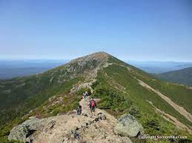
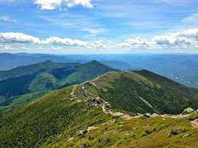
Franconia Ridge Loop
Dogs Leashed
Features Fall Colors • River/Creek • Views • Waterfall • Wildflowers
**Stay on Trail** once you are above treeline, the alpine zone is very fragile and you can kill the plants by simply stepping on them.
Overview
This loop offers everything you can expect. Steep hard rocky terrain, yet superb panoramic views on an exposed ridgeline for a long mile! During the descent, you'll cross several waterfalls.
This is a strenuous and steep trail. You'll want to be in shape for this one!
Need to Know
About 3/4 of the way to the top, you'll get to Greenleaf hut, which is perfect for filling your water bottle with drinkable tap water. The hut also sells things like muffins, candy and coffee. It's a perfect place to eat your lunch.
The hike to the top is really rocky, so please do not use sandals - hiking boots or running shoes are really necessary here. On the summit you are exposed to full weather so bring windstopping clothes.
During the descent you'll follow a river and cross several waterfall so you could bring some water purifier and refill your water bottle there.
Keep to weight to a minimum and yet never ran out of water!
Description
Since it is a loop, you can do it both ways, but I like to start with the Old Bridle Path trail that goes to the summit of Mt. Lafayette. Going this direction offers several advantages, like water refilling and the views seem to be at the right time and place.
I like to split this into three parts, where the first part (4 miles) is the ascent. Start with Old Bridle Path and Greenleaf Trail, from the Franconia Notch Parkway (wich is an AMC Shuttle stop). It's an easy start for the 2 miles and gets much steeper after. You'll get really nice view of Mt. Lafayette. After 2.9 miles you'll arrive at Greenleaf hut. A rest there will be appreciated just before the summit pitch.
The second section is a push between four summits with 360 views for the next mile and a half. Be sure to take a rest at the first summit. Starting early in the morning will assure that you get the full view. You don't want to rush this part. It's a great place to take pictures of the wild.
The last part of the route is 3 miles long and is simply wonderful. It is steeper than the ascent though, be prepared! The trail follows a river and passes several waterfalls. Since I always do this part last, I get the golden sun of the late afternoon blazing through the forest... simply great.
11 recommandé par les habitants
Franconia Ridge
Distance from our Lincoln Airbnb home = 10 min (8.1 miles)
Franconia Ridge Loop
Dogs Leashed
Features Fall Colors • River/Creek • Views • Waterfall • Wildflowers
**Stay on Trail** once you are above treeline, the alpine zone is very fragile and you can kill the plants by simply stepping on them.
Overview
This loop offers everything you can expect. Steep hard rocky terrain, yet superb panoramic views on an exposed ridgeline for a long mile! During the descent, you'll cross several waterfalls.
This is a strenuous and steep trail. You'll want to be in shape for this one!
Need to Know
About 3/4 of the way to the top, you'll get to Greenleaf hut, which is perfect for filling your water bottle with drinkable tap water. The hut also sells things like muffins, candy and coffee. It's a perfect place to eat your lunch.
The hike to the top is really rocky, so please do not use sandals - hiking boots or running shoes are really necessary here. On the summit you are exposed to full weather so bring windstopping clothes.
During the descent you'll follow a river and cross several waterfall so you could bring some water purifier and refill your water bottle there.
Keep to weight to a minimum and yet never ran out of water!
Description
Since it is a loop, you can do it both ways, but I like to start with the Old Bridle Path trail that goes to the summit of Mt. Lafayette. Going this direction offers several advantages, like water refilling and the views seem to be at the right time and place.
I like to split this into three parts, where the first part (4 miles) is the ascent. Start with Old Bridle Path and Greenleaf Trail, from the Franconia Notch Parkway (wich is an AMC Shuttle stop). It's an easy start for the 2 miles and gets much steeper after. You'll get really nice view of Mt. Lafayette. After 2.9 miles you'll arrive at Greenleaf hut. A rest there will be appreciated just before the summit pitch.
The second section is a push between four summits with 360 views for the next mile and a half. Be sure to take a rest at the first summit. Starting early in the morning will assure that you get the full view. You don't want to rush this part. It's a great place to take pictures of the wild.
The last part of the route is 3 miles long and is simply wonderful. It is steeper than the ascent though, be prepared! The trail follows a river and passes several waterfalls. Since I always do this part last, I get the golden sun of the late afternoon blazing through the forest... simply great.
Distance from our Lincoln Airbnb home = 15 min (12.4 miles)
Cannon-Lonesome Loop
Dogs Leashed
Features Views
Overview
On this hike you'll wind through beautiful woods and have great views of Mt Lafayette and the surrounding area. There is a lot of steep climbing as well as a peaceful hike around Lonesome Lake.
Need to Know
In winter, snowshoes/micro spikes/crampons are recommended. Coming back down Cannon in the snow and ice can be extremely treacherous (I spent a lot of time sliding on my butt, slowing down by strategically hitting/grabbing trees).
Description
This loop could be done either direction, but counter-clockwise is recommended.
Start at the parking for the Lafayette Campground Visitor Center and head south along the Franconia Notch State Park Recreational Trail where you'll run into another parking lot. From here, head west on Lonesome Lake Trail and hike up this until you reach the junction with Hi-Cannon Trail. Take a right onto Hi-Cannon Trail up to Kinsman Ridge Trail enjoying the views and the forest along the way. Near the top, right after the ladder, there are some excellent views of Mt. Lafayette. This section of the hike is extremely steep and strenuous, so be prepared and be careful.
At the junction with Kinsman Ridge Trail, hike up to the junction with the ski area. To the left is a short spur (Cannon Tower Spur) that leads to the observation tower; you can go up in the tower (signage says open weather permitting). There is an enclosed area at the top, but no matter what you can climb the steps to the upper deck. This is also a great time to grab some lunch at the mountain lodge provided you don't mind hiking down a short stretch of ski trail.
After a nice break, return to Kinsman Ridge Trail and hike down to the junction with Lonesome Lake Trail. In winter, this section may be very hard to descend safely. Turn onto Lonesome Lake Trail and continue to the junction with Lonesome Lake Hut Trail. Take Lonesome Lake Hut Trail, and Cascade Brook Trail around Lonesome Lake.
The Lonesome Lake Hut is one of the nicer huts on the AT that is staffed and has breakfast and dinner. Turn right back onto Lonesome Lake Trail at the junction with Cascade Brook Trail. Continue until you get back to the parking lot.
Lonesome Lake Loop
Lonesome Lake LoopDistance from our Lincoln Airbnb home = 15 min (12.4 miles)
Cannon-Lonesome Loop
Dogs Leashed
Features Views
Overview
On this hike you'll wind through beautiful woods and have great views of Mt Lafayette and the surrounding area. There is a lot of steep climbing as well as a peaceful hike around Lonesome Lake.
Need to Know
In winter, snowshoes/micro spikes/crampons are recommended. Coming back down Cannon in the snow and ice can be extremely treacherous (I spent a lot of time sliding on my butt, slowing down by strategically hitting/grabbing trees).
Description
This loop could be done either direction, but counter-clockwise is recommended.
Start at the parking for the Lafayette Campground Visitor Center and head south along the Franconia Notch State Park Recreational Trail where you'll run into another parking lot. From here, head west on Lonesome Lake Trail and hike up this until you reach the junction with Hi-Cannon Trail. Take a right onto Hi-Cannon Trail up to Kinsman Ridge Trail enjoying the views and the forest along the way. Near the top, right after the ladder, there are some excellent views of Mt. Lafayette. This section of the hike is extremely steep and strenuous, so be prepared and be careful.
At the junction with Kinsman Ridge Trail, hike up to the junction with the ski area. To the left is a short spur (Cannon Tower Spur) that leads to the observation tower; you can go up in the tower (signage says open weather permitting). There is an enclosed area at the top, but no matter what you can climb the steps to the upper deck. This is also a great time to grab some lunch at the mountain lodge provided you don't mind hiking down a short stretch of ski trail.
After a nice break, return to Kinsman Ridge Trail and hike down to the junction with Lonesome Lake Trail. In winter, this section may be very hard to descend safely. Turn onto Lonesome Lake Trail and continue to the junction with Lonesome Lake Hut Trail. Take Lonesome Lake Hut Trail, and Cascade Brook Trail around Lonesome Lake.
The Lonesome Lake Hut is one of the nicer huts on the AT that is staffed and has breakfast and dinner. Turn right back onto Lonesome Lake Trail at the junction with Cascade Brook Trail. Continue until you get back to the parking lot.
Distance from our Lincoln Airbnb home = 14 min (11.6 miles)
Bald Mountain/Artists Bluff Loop
Dogs Unknown
Features Geological Significance • Views
Overview
Both Bald Mountain and Artist Bluff offer wonderful views of the valley and of Cannon Mountain. However, while Artists is just slightly off of the trail, Bald Mountain requires a longer spur that is fairly difficult as it requires a fairly large amount of scrambling. This is a short but view rewarding loop.
Description
The trail beings at the parking area and begins to ascend quickly. After this short, moderate ascent, the trail forks with the Bald Mountain Spur to the left. This short spur is difficult as it ascends and requires scrambling up sheer rocks. However, once at the top, this spur offers incredible views of Cannon Mountain, Echo Lake, and the rest of Franconia Notch from the summit.
The climb down from Bald Mountain follows the same trail and includes the same hazards as the climb up. The loop then returns to the main trail. There are some more ups and downs until it leads to the Artist's Bluff Spur which is also to the left. This is a short spur that leads directly from the trail to the sheer cliffs of Artists Bluff at also provides spectacular views.
After returning to the trail from the bluffs, the trail descends very steeply. At the end of the descent, it takes a right onto the Loop Trail. For a connector trail, the Loop Trail is very well taken care of and is surprisingly scenic. The Loop Trail leads the loop to its terminus at the parking area.
41 recommandé par les habitants
Artist's Bluff Loop
2750 Profile RdDistance from our Lincoln Airbnb home = 14 min (11.6 miles)
Bald Mountain/Artists Bluff Loop
Dogs Unknown
Features Geological Significance • Views
Overview
Both Bald Mountain and Artist Bluff offer wonderful views of the valley and of Cannon Mountain. However, while Artists is just slightly off of the trail, Bald Mountain requires a longer spur that is fairly difficult as it requires a fairly large amount of scrambling. This is a short but view rewarding loop.
Description
The trail beings at the parking area and begins to ascend quickly. After this short, moderate ascent, the trail forks with the Bald Mountain Spur to the left. This short spur is difficult as it ascends and requires scrambling up sheer rocks. However, once at the top, this spur offers incredible views of Cannon Mountain, Echo Lake, and the rest of Franconia Notch from the summit.
The climb down from Bald Mountain follows the same trail and includes the same hazards as the climb up. The loop then returns to the main trail. There are some more ups and downs until it leads to the Artist's Bluff Spur which is also to the left. This is a short spur that leads directly from the trail to the sheer cliffs of Artists Bluff at also provides spectacular views.
After returning to the trail from the bluffs, the trail descends very steeply. At the end of the descent, it takes a right onto the Loop Trail. For a connector trail, the Loop Trail is very well taken care of and is surprisingly scenic. The Loop Trail leads the loop to its terminus at the parking area.
Distance from our Lincoln Airbnb home = 12 min (7.2 miles)
Beaver Brook
Dogs Leashed
Features Fall Colors • River/Creek • Views • Waterfall
Open year round. $5 forest service fee paid at a self-service kiosk at the trailhead.
Overview
This strenuous route is a New Hampshire classic. Though incredibly strenuous, especially at the start, this route exemplifies everything that a tough, New England hike should be.
Description
The Beaver Brook Trail begins with a steep climb alongside the Beaver Brook Cascades. There are occasional stairs and hand rungs, but most of the first mile is unassisted 34% grade with no switchbacks and steep drop-offs. At the top of the cascades is a shelter put together by the Dartmouth Outing Club that offers fantastic views of the Franconia and Kinsman Ridges.
From that point, the trail softens to a much more manageable 13% grade through a stunning evergreen forest. The last quarter mile of the trail is above tree-line, and visitors will move almost imperceptibly onto the Benton Trail for the last push to the top. The summit has incredible 360 views of New Hampshire and Vermont.
Flora & Fauna
The trail is mostly in evergreen forest, but it offers excellent views of the deciduous forests down below. The trailhead is by a pond in Kinsman Notch, and animals are often seen there.
Beaver Brook Trailhead
Lost River RoadDistance from our Lincoln Airbnb home = 12 min (7.2 miles)
Beaver Brook
Dogs Leashed
Features Fall Colors • River/Creek • Views • Waterfall
Open year round. $5 forest service fee paid at a self-service kiosk at the trailhead.
Overview
This strenuous route is a New Hampshire classic. Though incredibly strenuous, especially at the start, this route exemplifies everything that a tough, New England hike should be.
Description
The Beaver Brook Trail begins with a steep climb alongside the Beaver Brook Cascades. There are occasional stairs and hand rungs, but most of the first mile is unassisted 34% grade with no switchbacks and steep drop-offs. At the top of the cascades is a shelter put together by the Dartmouth Outing Club that offers fantastic views of the Franconia and Kinsman Ridges.
From that point, the trail softens to a much more manageable 13% grade through a stunning evergreen forest. The last quarter mile of the trail is above tree-line, and visitors will move almost imperceptibly onto the Benton Trail for the last push to the top. The summit has incredible 360 views of New Hampshire and Vermont.
Flora & Fauna
The trail is mostly in evergreen forest, but it offers excellent views of the deciduous forests down below. The trailhead is by a pond in Kinsman Notch, and animals are often seen there.